Archive Record
Images
Metadata
Object ID |
954.002 |
Scope & Content |
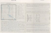
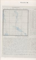
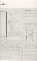
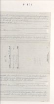
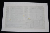
Weyerhaeuser Timber Co Timber Estimate and Land Examination of Section 2 Township 24 N Range 8, EWM. Is the timber thrifty or decaying? The old growth fir is very old and is not improving and should be converted into lumber. The cedar is not imporving but is fairly thrifty. Hemlock young and thrifty. Is there any logging or shingle bolt cutting now being carried on near this land? No. Has the land adjacent been logged off or burnt over? No. What, if any, is the danger from fire? The greatest danger from fire is from campers who came to fish in the lakes. Are there any improvements on this land, and is there an occupant? No improvements or occupants. But there are several old slashings, done years ago and now grown up- by people that homesteaded the land. Is there any visible sign of coal or other mineral deposits on this land? No visible sign of coal or other minerals. Has this land any special value on account of its topography as a route for railway, a logging road, or for dam sites or water power? The lakes on the west side of section could be used for the storage of logs if so desired. Topography NENE Clay loam and gravel, gently rolling NWNE Clay loam and rock, Very rolling SWNE Clay loam and gravel and rock, Rolling SENE Clay loam and gravel, gently rolling NENW Clay loam and rock, Very rolling NWNW Clay loam and rock, Very rolling SWNW Clay loam and rock, Steep slope W and SW SENW Clay loam and rock, Very rolling, Steep NESW Clay loam and gravel, Rolling NWSW Clay loam and gravel, Rolling SWSW Clay loam and gravel, Rolling SESW Clay loam and Rock, Very steep slope to west NESE Clay loam and gravel, Gently rolling NWSE Clay loam and gravel, Rolling SWSE Clay loam and rock, Extremely steep SESE Clay loam and rock, Steep and Rocky The surface is very badly broken with Fuller Mountain on the South and so many lakes and ponds and the greater part of the North 1/2 very rolling with rock buttes that are very steep. Of but little value for farming land. Logging Conditions The greater part of the fir is old growth yellow fir of good size and quality, and the North of section is fairly well timbered with it. THe land lays rather bad for convenient logging as it is very rough and rolling, and steep in places. Fuller Mountain on the south raises up very steep with rock cliffs on the east side and rock slide on the west. The North side of the section between the lake and the beaver pond is very badly broken with rock hups or buttes that are very steep. The East row of forties is only gently rolling. There is an immense lot of old dow fir in some places piled several deep that was blown down, probably at the sam time, many years ago. htese are badly decayed alothough when cut, ther may be a few logs in them, but cannot estimate them. The timber west of the beaver ponds can be handled south along the lake, and stream that runs from one lake to the other. THe timber East of the ponds can be handled south, and with other timber adjoining. THe timber on Fuller Mountain will be hard to handle as it is so steep and broken and will porblably not pay to handle at present. But there is no great amount on the mountain. The surface is covered with a thick growth of underbrush mostly of vinemaple, young hemlock and fir, huckleberrie, elder, and devilsclub and sallal. I find the section to be shor on the North, about 11 or 12 rods. |
Object Name |
Report |
Collection |
Snoqualmie Valley Historical Museum Special Collection Archives |
Title |
Weyerhaeuser Timber Co Timber Estimate and Land Examination of Section 2 Township 24 N Range 8, EWM |
Date |
July 1913 |
Year Range from |
1913 |
Year Range to |
1913 |
Search Terms |
1910s Weyerhaeuser Maps Fir Trees Cedar Tree Hemlock Tree Snoqualmie River North Fork |