Archive Record
Images
Metadata
Object ID |
030.143 |
Scope & Content |
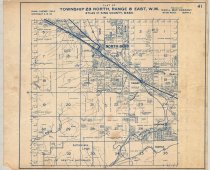
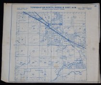
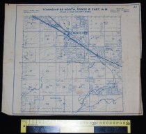
Map: #41 Plat of North Bend, Edgewick, Tanner, Rattlesnake Ledge. Middle Fork. Snoqualmie River. Rattlesnake Ledge, Middle Fork Snoqualmie River, Sunset Hwy. Primary State Hwy., No. 2, Meadowbrook, C.M.S.T.P &P. Railroad, City of Seattle Watershed, Township 23 north, Range 8 east, WD. Published by Kroll Maps, Seattle WA. Blue printing on white paper. 14 x 17" long. |
Object Name |
Map |
Collection |
Snoqualmie Valley Historical Museum Special Collection Archives |
Title |
Plat |
Caption |
030.143 |
Search Terms |
North Bend Edgewick Tanner Highway 2 Meadowbrook Rattlesnake Ridge CM&SP Railroad Middle Fork Snoqualmie River Sunset Highway Seattle City Light Power Plant, Cedar Falls, Washington Cedar Falls/Moncton Cedar River Watershed Maps |