Archive Record
Images

Metadata
Object ID |
954.003 |
Scope & Content |
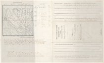
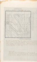
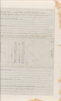
Weyerhaeuser Timber Co Timber Estimate and Land Examination of Section 3 Township 24 N Range 8, EWM. Is the timber thrifty or decaying? Part of the timber is very conkey and from examining windfalls find them effected with ground rot as all are broken at the ground Is there any logging or shingle bolt cutting now being carried on near this land? None. Has the land adjacent been logged off or burnt over? Not any. What, if any, is the danger from fire? At present there is not much danger. However there is a lot of down small Hemlock. Caused by heavy snow last season which is green at present if this timber become dead it would create plenty of material for fires. Are there any improvements on this land, and is there an occupant? None. Is there any visible sign of coal or other mineral deposits on this land? None visible. Has this land any special value on account of its topography as a route for railway, a logging road, or for dam sites or water power? On this section a good route can be found for a railroad from the South to the North. Topography NENE Clay stone steep sloping 200 NWNE Clay stone steep sloping 200 SWNE Clay stone steep sloping 200 SENE Clay stone steep sloping 200 NENW Clay gravel rolling sloping 300 NWNW Clay gravel West 1/2 level 500 SWNW Clay gravel West 1/2 level 500 SENW Clay gravel Rolling Sloping 350 NESW Clay gravel Rolling Sloping 350 NWSW Clay gravel nearly level 500 SWSW Clay gravel nearly level 400 SESW Clay gravel rolling 350 NESE Clay stone steep 200 NWSE Clay stone rolling 350 SWSE Clay stone rolling 350 SESE Clay stone Steep Rolling 200 Logging Conditions This timber can be logged to the South. A very good route for a railroad can be found in and across this section along the East line of this section around the shore of Echo Lake (Boyle Lake). The surface is gentle rolling and sloping on the West part, on the East part the surface is steep sloping from dividing ridge as a whole the Timber can be logged to good advantage and will handle partly to the East and partly to the West of this section. General Note: This section don't contain the acreage given on the township plat on the East boundary owing to the less variation on the south boundary is about 73 chains on the west boundary the distance is given as 69.34 chains and the plat gives the fraction on the North as 34.75 acres which in not correct. |
Object Name |
Report |
Collection |
Snoqualmie Valley Historical Museum Special Collection Archives |
Date |
June 1913 |
Year Range from |
1913 |
Year Range to |
1913 |
Search Terms |
1910s Weyerhaeuser Maps Fir Trees Cedar Tree Hemlock Tree Snoqualmie River North Fork |
People |
Dodwell, AW |