Search Term Record
Metadata
Name |
Cascade Mountains |
Details |
The Cascade Range (or Cascades) is a major mountain range of western North America, extending from southern British Columbia through Washington and Oregon to Northern California. It includes both non-volcanic mountains, such as the North Cascades, and the notable volcanoes known as the High Cascades. The small part of the range in British Columbia is referred to as the Canadian Cascades or, locally, as the Cascade Mountains. The latter term is also sometimes used by Washington residents to refer to the Washington section of the Cascades in addition to North Cascades, the more usual American term, as in North Cascades National Park. The Cascades are part of the Pacific Ring of Fire, the ring of volcanoes and associated mountains around the Pacific Ocean. All of the known historic eruptions in the contiguous United States have been from Cascade volcanoes. The two most recent were Lassen Peak in 1914 to 1921 and a major eruption of Mount St. Helens in 1980. Minor eruptions of Mount St. Helens have also occurred since, most recently in 2006. The Cascades extend from Lassen Peak (also known as Mount Lassen) in northern California to the confluence of the Nicola and Thompson Rivers in British Columbia. The Fraser River separates the Cascades from the Coast Mountains. The highest volcanoes of the Cascades are called the High Cascades and dominate their surroundings, often standing twice the height of the nearby mountains. They often have a visual height (height above nearby crestlines) of 1 mi (1.6 km) or more. The highest peaks, such as the 14,411 ft (4,392 m) high Mount Rainier, dominate their surroundings for 50 to 100 mi (80 to 160 km). The northern part of the range, north of Mount Rainier, is known as the North Cascades in the United States but is formally named the Cascade Mountains north of the Canada – United States border, reaching to the northern extremity of the Cascades at Lytton Mountain. Overall, the North Cascades and southwestern Canadian Cascades are extremely rugged, with many of the lesser peaks steep and glaciated, with valleys quite low relative to its peaks and ridges, resulting in great local relief. The southern part of the Canadian Cascades, particularly the Skagit Range, is geologically and topographically similar to the North Cascades, while the northern and northeastern parts are less glaciated and more plateau-like in character, resembling nearby areas of the Thompson Plateau. Because of the range's proximity to the Pacific Ocean and the region's prevailing westerly winds, precipitation is substantial, especially on the western slopes, with annual accumulations of up to 150 in (3,800 mm) in some areas. For example, Mount Baker recorded the largest single-season snowfall on record in the world in 1999&, with heavy snowfall as low as 2,000 ft (610 m).[citation needed] It is not uncommon for some places in the Cascades to have over 200 in (5,100 mm) of snow accumulation, such as at Lake Helen (near Lassen Peak), one of the snowiest places in the world.[citation needed] Most of the High Cascades are therefore white with snow and ice year-round. The western slopes are densely covered with Douglas-fir, Western Hemlock and Red alder, while the drier eastern slopes are mostly Ponderosa Pine, with Western Larch at higher elevations. Annual rainfall drops to 9 in (230 mm) on the eastern foothills due to a rainshadow effect. Beyond the foothills is an arid plateau that was created 16 million years ago as a coalescing series of layered flood basalt flows. Together, these sequences of fluid volcanic rock form a 200,000 sq mi (520,000 km2) region out of eastern Washington, Oregon, and parts of Northern California and Idaho called the Columbia River Plateau. The Columbia River Gorge is the only major break in the American part of the Cascades. When the Cascades started to rise 7 million years ago in the Pliocene, the Columbia River drained the relatively low Columbia River Plateau. As the range grew, erosion from the Columbia River was able to keep pace, creating the gorge and major pass seen today. The gorge also exposes uplifted and warped layers of basalt from the plateau. |
Related Records
-
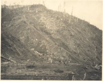
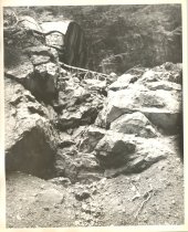
PO.039.0518 - Logs being moved off hillside via railroad car.
Print, Photographic
Record Type: Photo
-
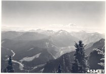
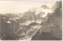
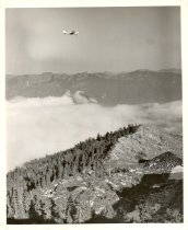
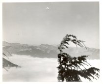
PO.039.0526 - Aerial view of South Cascade Crest looking South from Snoqualmie Mountain.
Print, Photographic
Record Type: Photo
-
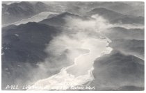
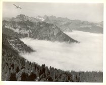
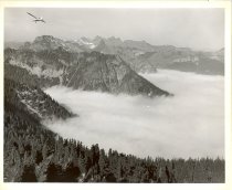
PO.075.0495 - Lake Keechelus and Lake Kachess, Wash. Aerial view. Two lakes in Cascade Mountains. Clouds above lakes and mountains quite hazy.
Postcard
Record Type: Photo
-
-
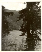
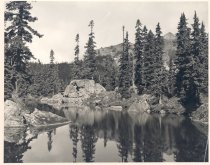
PO.304.0019 - An unnamed lake near Cascade Crest Divide. Photographer, Henry A. Hansmeier 8 x 10" black and white glossy The picture is of a small lake in the mountains. There are large rocks around the edge. Trees are growing along the shore. Their reflection can be seen in the lake. Mountains can be seen in the background.
Print, Photographic
Record Type: Photo
-
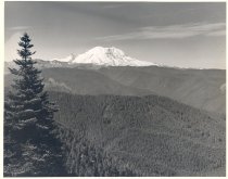
PO.304.0021 - Mount Rainier from North. 8 x 10" black and white glossy H. Hansmeier Photographer The picture is of the top of Mt. Rainier as it is seen from a distance looking over timbered mountains. The top of the mountain is snow covered. There is a blue spruce tree at the lower left of the picture.
Print, Photographic
Record Type: Photo
-
-
-
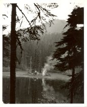
PO.374.0018 - Source Lake, Snoqualmie Pass. Source Lake where the South Fork of the Snoqualmie River began.
Print, Photographic
Record Type: Photo

-
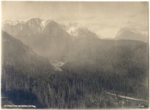
PO.406.0001 - _50. Little Index and General Panorama View along Skykomish River, Wash. Darius Kinsey, 1607 E Alder St. Seattle, Wash.
Print, Photographic
Record Type: Photo
-
-
-
-
-
-
-
-
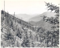
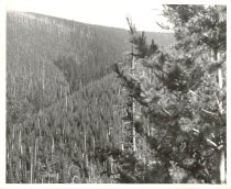
PO.493.0230 - Natural regrowth after 1910 fire. Old 1910 burn outlined by fire billed white snags. Looking North toward Lester, WA. c 1940. HA Hansmeier photo.
Print, Photographic
Record Type: Photo
-
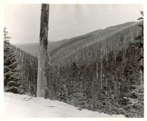
PO.493.0231 - Natural regrowth after 1910 fire. Ridge about 4500 ft elevation. c 1940. HA Hansmeier photo.
Print, Photographic
Record Type: Photo
-