Search Term Record
Metadata
Name |
Cedar River |
Details |
The Cedar River is about 45 miles (72 km) long, it originates in the Cascade Range near Abiel Peak, Meadow Mountain, and Yakima Pass, along the King and Kittitas countyline. Several headwater streams join in the high mountains, then the Cedar River flows generally west. It is impounded in Chester Morse Lake, a natural lake that was dammed in 1900 for use as a water storage reservoir. The Rex River joins the Cedar in Chester Morse Lake, as do the two forks of the Cedar River, the north and south forks. Below the lake the Cedar River flows through a smaller lake called Masonry Pool. Below Masonry Pool the Cedar River flows by two former railroad sites, Bagley Junction and Trule. Then the river exits the Cedar River Watershed at Landsburg where pipelines route water to the Seattle area. Below the Cedar River Watershed area the river flows west and north, past the city of Maple Valley and Renton. At Renton the Cedar River empties into the southern end of Lake Washington. Its waters eventually enter Puget Sound via the Lake Washington Ship Canal.. The upper Cedar River watershed is a protected area called the Cedar River Watershed. About 90,000 acres (364 km²) in size, it is owned by the City of Seattle. The Cedar River Watershed provides drinking water for 1.4 million people in the greater Seattle area. About two-thirds of King County uses water from the Cedar River Watershed, over 100 million US gallons (380,000 m³) per day. The reservoirs and pipeline infrastructure is owned and operated by Seattle Public Utilities. Public access is restricted and the area is managed as a wilderness in order to protect water quality. Chester Morse Lake is the main storage reservoir of the Cedar River Watershed system. Pipelines route water to the Seattle area from Landsburg, at the western edge of the protected watershed area. Before 1912 the Cedar River did not empty into Lake Washington but rather into the Black River. The Black River drained the southern end of Lake Washington, flowing south then west to join the Green River. The Black-Green confluence created the Duwamish River, which emptied into Elliott Bay. In 1911 there was a major flood along the lower Cedar River. This prompted the city of Renton to make a diversion canal so that the Cedar River emptied into Lake Washington instead of the Black River. The diversion was completed in 1912. The Cedar River's water, via Lake Washington, still ultimately flowed into the Black River, Duwamish River, and into Elliott Bay. In 1916 the Lake Washington Ship Canal's Montlake Cut was finished, connecting Lake Washington and Lake Union. The water level of Lake Washington dropped 8.8 feet (2.7 m), to the level of Lake Union. As a result the outlet of Lake Washington became the Ship Canal instead of the Black River. The Black River dried up and no longer exists.[7] Thus today the Cedar River's water enter Lake Washington and then pass through the Ship Canal to Puget Sound, rather than into Elliott Bay via the Duwamish River. Anadromous fish, such as salmon, which used to migrate up the Duwamish and Black rivers to reach the Cedar River, now migrate through the Ship Canal and Lake Washington. The upper Cedar River flows through a region of deep and porous glacial till. A large amount of water seeps into the ground, forming an aquifer. Most of this underground water eventually returns to the surface as springs, flowing mainly into the Cedar River as well as the Snoqualmie River and Rattlesnake Lake. This process acts as a kind of natural water filtration system. As a result, the Cedar River is one of the few rivers in the United States used for drinking water without requiring specially fabricated filtration. The watershed also has an education center. Here you can learn about the issues that involves the region's drinking water, forest and wildlife. |
Related Records
-
-
-
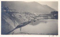
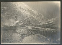
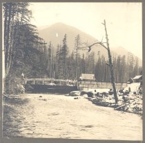
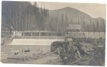
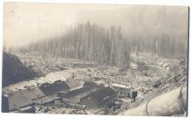
PO.094.0003 - Cedar River and site of Dam. Cedar Falls River showing location of first City Light Dam on the river. Date in ink, 4-18-15. Shows stumps on hillside with wooden towers and pipe, braced, going down into river size, 2-1/8" x 4-1/4" long
Snapshot
Record Type: Photo
-
-
-
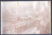
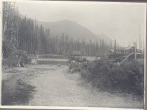
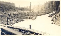
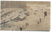
PO.1127.0186 - Construction during Chester Morse Dam project.
Print, Photographic
Record Type: Photo
-
-
-
-
-
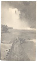
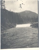
PO.178.0457 - The Cedar Falls. The picture is an original of the cedar falls The water is white where it comes down and into the river. There is a large loge in the water in the foreground of the picture
Print, Photographic
Record Type: Photo
-
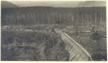
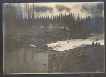
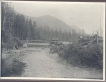
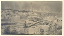
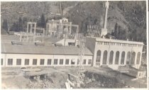
PO.178.0467 - The picture shows the partially built dam. The forms of the concrete are still in place, and the large pipe leading to a team stationary engine. The banks of the river have been cleared, with many logs and much slag still on the dam.
Print, Photographic
Record Type: Photo
-
-
-
-
-
-
-
-