Search Term Record
Metadata
Name |
Puget Sound |
Details |
Puget Sound is a sound in the state of Washington and part of the Salish Sea. It is a complex estuarine system of interconnected marine waterways and basins, with one major and one minor connection to the Strait of Juan de Fuca and the Pacific Ocean — Admiralty Inlet being the major connection and Deception Pass being the minor. Flow through Deception Pass accounts for about 2% of the total tidal exchange between Puget Sound and the Strait of Juan de Fuca. Puget Sound extends approximately 100 miles (160 km) from Deception Pass in the north to Olympia, Washington in the south. Its average depth is 205 feet (62 m) and its maximum depth, off Point Jefferson between Indianola and Kingston, is 930 feet (280 m). The depth of the main basin, between the southern tip of Whidbey Island and Tacoma, Washington, is approximately 600 feet (180 m). The term "Puget Sound" is used not just for the body of water but also the general region centered on the sound. There are various definitions of the extent and boundaries of Puget Sound. In 1792 George Vancouver gave the name "Puget's Sound" to the waters south of the Tacoma Narrows, in honor of Peter Puget, a lieutenant accompanying him on the Vancouver Expedition. The name later came to be used for the waters north of Tacoma Narrows as well. The USGS defines Puget Sound as all the waters south of three entrances — the main entrance at Admiralty Inlet being a line between Point Wilson, on the Olympic Peninsula, and Point Partridge, on Whidbey Island; a second entrance at Deception Pass being a line from West Point, on Whidbey Island, to Deception Island and Rosario Head, on Fidalgo Island; and a third entrance at the south end of the Swinomish Channel, which connects Skagit Bay and Padilla Bay. Under this definition, Puget Sound includes the waters of Hood Canal, Admiralty Inlet, Possession Sound, Saratoga Passage, and others. It does not include Bellingham Bay, Padilla Bay, the waters of the San Juan Islands or anything farther north. Another definition, given by NOAA, subdivides Puget Sound into five basins or regions. Four of these correspond to areas within the USGS definition, but the fifth one, called "Northern Puget Sound" includes a large additional region. It is defined as bounded to the north by the international boundary with Canada, and to the west by a line running north from the mouth of the Sekiu River on the Olympic Peninsula. Under this definition significant parts of the Strait of Juan de Fuca and the Strait of Georgia are included in Puget Sound, with the international boundary marking an abrupt and hydrologically arbitrary limit. According to Arthur Kruckeberg, the term "Puget Sound" is sometimes used for waters north of Admiralty Inlet and Deception Pass, especially for areas along the north coast of Washington and the San Juan Islands, essentially equivalent to NOAA's "Northern Puget Sound" subdivision described above. Kruckeberg uses the term "Puget Sound and adjacent waters". An alternative term for Puget Sound, still used by only some Native Americans and environmental groups, is Whulge (or Whulj), an Anglicization of the Lushootseed name 'WulcH, which means "Salt Water".Since 2009 the term Salish Sea has been established by the United States Board on Geographic Names as the collective waters of Puget Sound, the Strait of Juan de Fuca, and the Strait of Georgia. Sometimes the terms "Puget Sound" and "Puget Sound and adjacent waters" are used for not only Puget Sound proper but also for waters to the north, such as Bellingham Bay and the San Juan Islands region. George Vancouver explored Puget Sound in 1792. Vancouver claimed it for Great Britain on 4 June 1792, naming it for one of his officers, Lieutenant Peter Puget. After 1818 Britain and the United States, which both claimed the Oregon Country, agreed to "joint occupancy", deferring resolution of the Oregon boundary dispute until the 1846 Oregon Treaty. Puget Sound was part of the disputed region until 1846, after which it became US territory. American maritime fur traders visited Puget Sound in the early 19th century. The first European settlement in the Puget Sound area was Fort Nisqually, a fur trade post of the Hudson's Bay Company (HBC) built in 1833. Fort Nisqually was part of the HBC's Columbia District, headquartered at Fort Vancouver. The Puget Sound Agricultural Company, a subsidiary of the HBC, established farms and ranches near Fort Nisqually. British ships such as the Beaver, exported foodstuffs and provisions from Fort Nisqually. The first American settlement on Puget Sound was Tumwater. It was founded in 1845 by Americans who had come via the Oregon Trail. The decision to settle north of the Columbia River was made in part because one of the settlers, George Washington Bush, was considered black and the Provisional Government of Oregon banned the residency of mulattoes but did not actively enforce the restriction north of the river. In 1853 Washington Territory was formed from part of Oregon Territory. In 1888 the Northern Pacific railroad line reached Puget Sound, linking the region to eastern states. |
Related Records
-
-
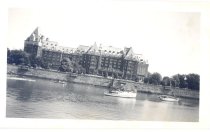
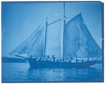
PO.574.0512 - Empress Hotel in Victoria, BC, with boats in the harbor. August, 1947
Print, Photographic
Record Type: Photo
-
-
-
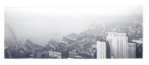
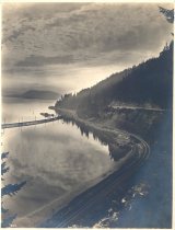
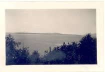
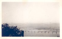
PO.981.0001 - Canada. July 1946. Puget Sound. Mary Jane Nelson Album Photograph.
Print, Photographic
Record Type: Photo
-
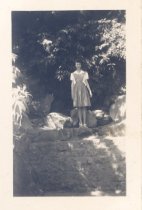
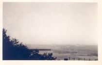
PO.981.0002 - Canada. July 1946. Lotti Nelson looking at Puget Sound. (She was looking at view in image PO.981.001) Mom looking at the picture above only it was real. Mary Jane Nelson Album Photograph.
Print, Photographic
Record Type: Photo
-
PO.981.0003 - Canada. July 1946. Mary Jane Nelson looking at Puget Sound. (She was looking at view in image PO.981.001) Me looking at the picture. Mary Jane Nelson Album Photograph.
Print, Photographic
Record Type: Photo
-
PO.981.0032 - Port Angles, the Fleets in. Battle ships in the bay before the war. Mary Jane Nelson Album Photograph.
Print, Photographic
Record Type: Photo
-
PO.981.0033 - Port Angles, the Fleets in. Battle ships in the bay before the war. Mary Jane Nelson Album Photograph.
Print, Photographic
Record Type: Photo
-
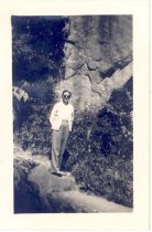
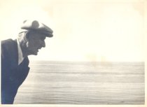
PO.981.0052 - Dad (Jim Nelson) on Marine Drive Victoria, BC. White haze is cloud and fog bank covering the coast of Washington, USA. Mary Jane Nelson Album Photograph.
Print, Photographic
Record Type: Photo
-