Photo Record
Images
Metadata
Object ID |
PO.114.0040 |
Description |
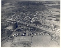
Aerial view of North Bend 1946. From Park St to Si View to Silver Creek to Tollgate. Aerial view of North Bend including South Fork of the Snoqualmie River in upper left. Sunset Highway runs through the center from left to right. Trees in top of picture. Fields in foreground. The view is to the north. |
Object Name |
Print, Photographic |
Collection |
Snoqualmie Valley Historical Museum Photograph Collection |
Photographer |
Simmons, RD |
Date |
1946 |
Year Range from |
1946 |
Year Range to |
1946 |
Search Terms |
North Bend Ballarat St, North Bend, Washington 1940s Aerials Bendigo Blvd, North Bend, Washington Sydney St, North Bend, Washington Park St, North Bend Tollgate First Ave, North Bend Second Ave, North Bend, Washington Third Ave, North Bend, Washington Fourth St, North Bend, Washington Main St, North Bend, Washington |