Photo Record
Images
Metadata
Object ID |
PO.014.0012 |
Description |
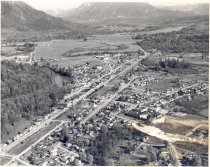
Aerial View of the town of Snoqualmie c 1956-1957. Taken from the North end of town; all the way to the Snoqualmie Pass visible. Highway 202 can be seen going through the town and on to North Bend. The river is at the left, with trees along the banks. A train is on the tracks at the lower left of the picture. The streets are not laid out in square blocks, some of the blocks are odd shaped, and some are triangular shape. Open area can be seen east of Meadowbrook Drive. |
Object Name |
Print, Photographic |
Collection |
Snoqualmie Valley Historical Museum Photograph Collection |
Title |
Aerial View of the town of Snoqualmie c 1956-1957 |
Year Range from |
1956 |
Year Range to |
1957 |
Search Terms |
1950s Aerials Falls Ave, Snoqualmie, Washington Farming Farms King St, Snoqualmie, Washington Meadowbrook Meadowbrook Bridge Meadowbrook Farm Mount Si Mount Si High School North Bend Railroad Ave, Snoqualmie, Washington Railroad tracks Railroads River St, Snoqualmie, Washington Snoqualmie Snoqualmie Bank Snoqualmie Elementary School Snoqualmie Falls Lumber Co Snoqualmie Falls Lumber Co Mill Snoqualmie Methodist Church Snoqualmie Northern Pacific Depot Snoqualmie River Snoqualmie Town Hall Snoqualmie Valley Trains |